Grassland birds are vanishing faster than nearly any other bird group in North America. If you’re monitoring these populations, you need a survey method that delivers reliable, repeatable data. Point count surveys have become the gold standard for tracking grassland bird populations because they balance statistical rigor with field practicality.
Point count surveys for grassland birds involve stationary observation periods at predetermined locations where observers record all birds detected within a fixed radius. Success depends on proper timing, standardized protocols, weather considerations, observer training, and consistent data recording. These surveys provide population trends, species richness data, and habitat association insights critical for conservation planning in declining grassland ecosystems.
Understanding the Point Count Method
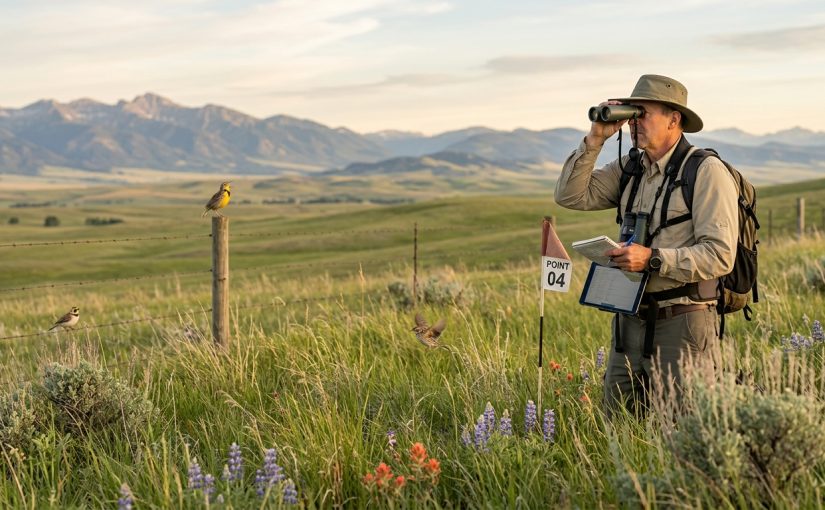
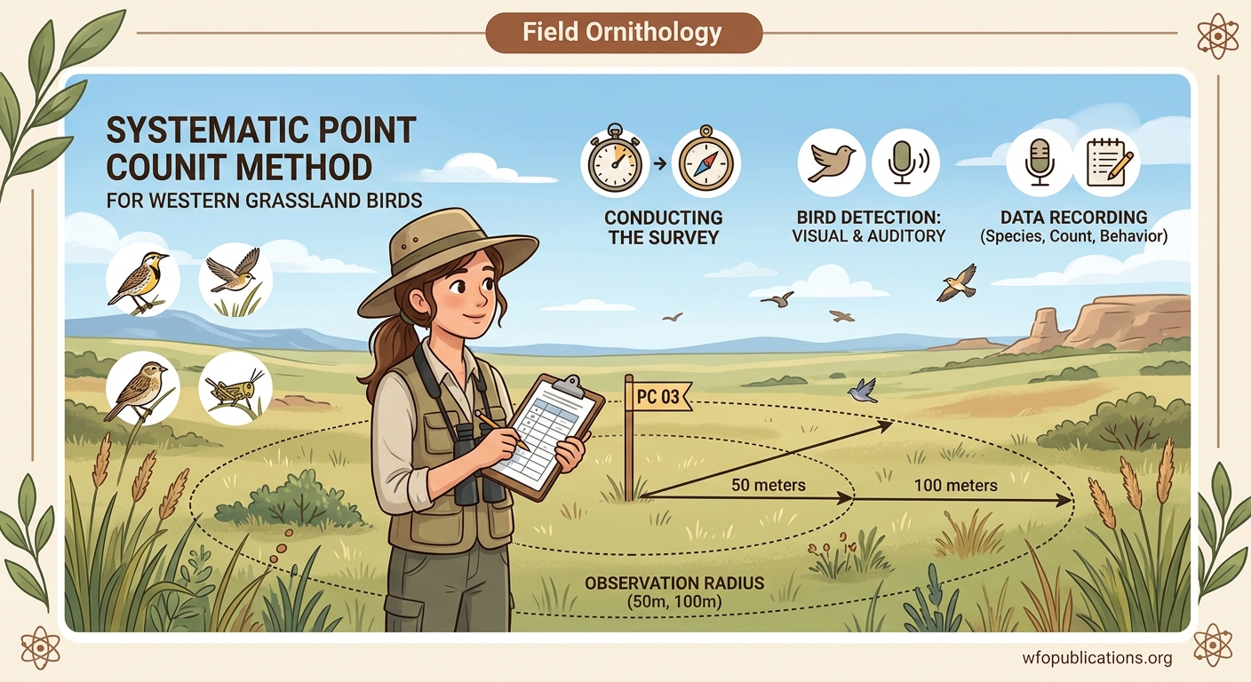
Point counts work by having an observer stand at a fixed location and record every bird detected during a set time period. The method is straightforward but demands careful attention to protocol.
You establish survey points across your study area based on habitat type, accessibility, and research questions. Each point becomes a sampling unit that you’ll revisit multiple times throughout the season or across years.
The observer remains stationary. This eliminates the double-counting problems that plague transect surveys in open habitats where birds can fly ahead of you. In grasslands, where visibility extends for hundreds of meters, staying put matters.
Most protocols use a five-minute count period. Some researchers prefer ten minutes for rare species detection. The trade-off is simple: longer counts detect more species but reduce the number of points you can survey in a morning.
Distance estimation separates basic presence data from density calculations. You’ll typically record birds in distance bands: 0-50m, 50-100m, and beyond 100m. Some protocols use unlimited radius counts. Others cap detection at 100m or 200m to reduce distance estimation errors.
Timing Your Surveys for Maximum Detection
Grassland birds sing most actively during early morning hours. Start your counts at sunrise or within thirty minutes after. This window captures peak vocal activity for most species.
The breeding season offers the best detection rates. Males establish territories and sing persistently. For western grasslands, this typically means late April through early July, though timing shifts with latitude and elevation.
Survey each point multiple times during the season. Three visits represent the minimum for occupancy modeling. Four to six visits improve detection probability estimates for less common species.
Space your visits at least seven days apart. This interval allows for turnover in migrant species and reduces the chance of counting the same individual on consecutive surveys.
Avoid surveys during poor weather. Wind above 20 km/h masks vocalizations and reduces detection rates. Rain suppresses bird activity. Fog limits visual detection. If conditions deteriorate during your survey route, note the change and consider whether to continue or reschedule.
Temperature affects bird activity differently across species. Extreme heat (above 30°C) reduces singing in many grassland birds. Cold mornings following weather fronts often trigger increased vocal activity.
Setting Up Your Survey Points
Point spacing prevents double-counting between adjacent stations. A minimum of 250 meters works for most grassland species. Some protocols use 400-meter spacing for areas with high bird densities or when surveying species with large territories.
Randomized point placement reduces bias but often proves impractical in real landscapes. Systematic grids offer a compromise. You can stratify points by habitat type to ensure coverage of different grassland conditions.
Mark each point with GPS coordinates accurate to within five meters. Physical markers help relocate points across seasons, but avoid anything that alters bird behavior or creates perch sites.
Record habitat variables at each point. Vegetation height, grass density, shrub cover, and distance to edges all influence bird communities. Measure these variables within your count radius using standardized methods.
Document potential detection biases. Background noise from roads, streams, or wind turbines affects what you can hear. Topography creates blind spots. Note these factors so you can account for them during analysis.
Field Protocol Essentials
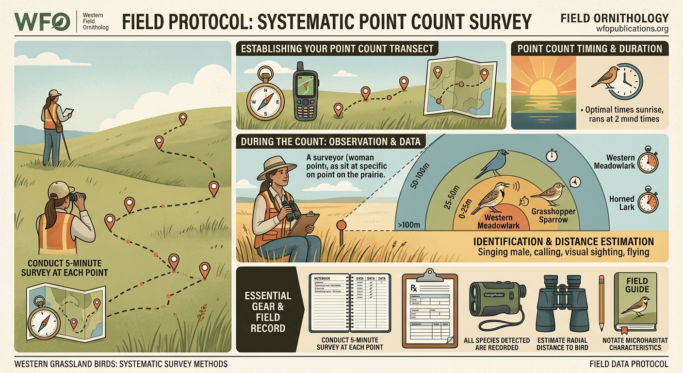
Arrive at each point quietly. Allow a settling period of one minute before starting your count. This lets birds resume normal behavior after your approach.
Use a stopwatch or timer app. Consistency in count duration matters more than you might think. Even thirty seconds of variation affects detection rates.
Record every individual detected by sight or sound. Note the species, detection method (song, call, visual), sex if determinable, and distance band. Some protocols distinguish between birds detected in the first three minutes versus the final two minutes.
Flyovers present a judgment call. Most protocols exclude birds clearly flying over without using the habitat. Include birds that land, sing, or show territorial behavior during the count period.
“The most common mistake I see is observers trying to identify every bird before moving on. Let some birds go. Record what you know with certainty and keep your attention on the full count radius. You’ll detect more birds by staying alert than by fixating on one difficult identification.” – Field ornithologist with 20+ years of grassland survey experience
Carry a voice recorder as backup. You can verify identifications later and catch vocalizations you might miss while writing. Some researchers record every count, though this creates substantial post-processing work.
Common Mistakes and Solutions
| Mistake | Why It Happens | Solution |
|---|---|---|
| Inconsistent distance estimation | Observers lack calibration | Practice estimating distances with a rangefinder before surveys begin |
| Surveying too late in morning | Logistical constraints | Start earlier or reduce number of points per route |
| Recording birds outside count period | Eagerness to document detections | Use timer alerts and strictly enforce start/stop times |
| Failing to note weather changes | Focus on birds rather than conditions | Record weather at each point, not just route start |
| Double-counting mobile individuals | Birds move between distance bands | Note individual movements and record only initial detection location |
| Inconsistent observer effort | Fatigue over long routes | Limit routes to 8-12 points maximum per morning |
Training and Observer Consistency
Your ability to identify grassland birds by song determines survey quality. Many grassland species look similar but sound distinct. Spend time learning vocalizations before field season starts.
Conduct calibration exercises with experienced observers. Visit the same points and compare detection rates. Differences above twenty percent suggest training needs or protocol interpretation issues.
Some species groups require special attention. Female grassland birds vocalize less frequently than males. Juvenile birds produce calls that differ from adults. Migrant species passing through can confuse abundance estimates.
Distance estimation improves with practice. Set up markers at known distances in grassland habitat. Practice estimating distances to singing birds, then verify with a rangefinder. Your brain calibrates surprisingly fast with feedback.
Observer effects represent a real source of variation in point count data. Hearing ability, experience level, and even personality (some observers are more willing to record uncertain identifications) all influence results. Acknowledge these effects in your analysis or design.
Data Recording Best Practices
Use standardized datasheets. Digital forms on tablets work well but carry backup paper sheets. Dead batteries happen at the worst times.
Essential data fields include:
- Point identification number
- Date and start time
- Observer name
- Weather conditions (temperature, wind speed, cloud cover, precipitation)
- Species detected
- Count of individuals per species
- Detection method (song, call, visual)
- Distance band
- Time interval (if using multiple intervals)
Record data during the count, not after. Memory fails faster than you expect. A bird detected at four minutes becomes uncertain by the time you finish the five-minute period.
Code uncertain identifications separately. Use “probable” or “possible” categories rather than guessing. These records help during analysis when you’re deciding whether to include marginal detections.
Photograph or audio-record unusual sightings. Rare species records need verification. Even common species showing unexpected behavior warrant documentation.
Analyzing Your Survey Data
Raw counts provide basic presence and relative abundance information. You can compare counts across points or years, but interpretation requires caution. Detection probability varies by species, habitat, weather, and observer.
Occupancy modeling accounts for imperfect detection. You need multiple visits to the same points. The models estimate both occupancy (is the species present?) and detection probability (if present, did we detect it?).
Distance sampling converts detections into density estimates. You model how detection probability declines with distance, then use that relationship to estimate true density. This requires larger sample sizes and careful distance estimation.
Trend analysis needs multi-year data. Three years represent a minimum. Five to ten years reveal meaningful population changes for most species. Annual variation can mask trends in shorter datasets.
Adapting Protocols for Specific Research Questions
Rare species detection may require longer count periods or more visits. Ten-minute counts with six visits per season improve detection for species occurring at low densities.
Habitat association studies need careful point placement across habitat gradients. Stratified random sampling ensures coverage of different conditions while maintaining statistical validity.
Before-after impact assessments require baseline data from multiple years before disturbance. Control sites in similar habitat provide comparison points for isolating treatment effects from regional population trends.
Community composition studies benefit from unlimited radius counts. You sacrifice density estimation precision but gain information on species richness and diversity.
Migration monitoring demands different timing. You might survey weekly during peak migration periods rather than spacing visits across the breeding season.
Equipment Checklist
Your field kit should include:
- Binoculars (8x or 10x magnification)
- Field guide or birding app
- GPS unit or smartphone with GPS
- Timer or stopwatch
- Datasheets and pencils
- Clipboard or field notebook
- Weather meter (wind speed, temperature)
- Voice recorder (optional but recommended)
- Rangefinder for distance calibration
- Backup batteries or power bank
Clothing matters in grasslands. Long pants protect against ticks and vegetation. Light colors help you spot ticks. A wide-brimmed hat reduces sun glare. Layers accommodate temperature changes between pre-dawn starts and mid-morning finishes.
Safety Considerations in Grassland Habitats
Grasslands present unique hazards. Rattlesnakes occur in many western grasslands. Watch where you step, especially in rocky areas or near shrubs. Carry a first aid kit with snake bite instructions.
Ticks transmit diseases across much of North America. Check yourself thoroughly after each field day. Use permethrin-treated clothing during peak tick season.
Lightning poses serious risk in open grasslands. Monitor weather forecasts. Postpone surveys if thunderstorms threaten. If caught in the open during a storm, crouch low in a depression, away from isolated trees or fence lines.
Heat stress develops quickly in exposed grasslands. Carry more water than you think you need. Start early to avoid peak heat. Know the signs of heat exhaustion.
Let someone know your survey route and expected return time. Cell coverage is often poor in remote grasslands. A satellite communicator provides emergency backup.
Building a Long-Term Monitoring Program
Consistency trumps perfection. Use the same points, same protocols, same timing across years. Small methodological improvements matter less than maintaining comparability with previous data.
Train new observers carefully. Have them survey alongside experienced observers for at least one full season. Maintain detailed protocol documentation so methods remain consistent as staff changes.
Archive your data properly. Use standardized formats compatible with regional or national databases. Back up data in multiple locations. Future researchers (including yourself) will thank you.
Contribute data to broader monitoring networks. Programs like the North American Breeding Bird Survey provide context for your local results. Your data helps answer landscape-scale questions about grassland bird conservation.
Making Your Data Count for Conservation
Point count surveys generate numbers, but conservation needs context. Connect your findings to management questions. Which habitats support the highest densities? How do populations respond to grazing regimes or fire? What species are declining?
Share results with land managers. Written reports matter, but face-to-face conversations often drive action. Bring photos. Show maps. Explain what the numbers mean for the birds and the landscape.
Publish findings even from small studies. Regional journals and wildlife society bulletins reach practitioners who need local information. Your data on habitat associations or population trends fills knowledge gaps.
Grassland bird conservation depends on understanding where birds occur, how populations change, and what factors drive those changes. Point count surveys provide that foundation, but only if we conduct them with care and use the results to inform real decisions.
Putting Your Surveys into Action
You now have the framework for conducting rigorous point count surveys. The method is simple in concept but demands attention to detail in execution. Start small if you’re new to the protocol. A dozen well-surveyed points teach you more than fifty poorly executed counts.
Practice your skills before the breeding season arrives. Learn the songs. Calibrate your distance estimation. Test your data recording system. The investment pays off when birds are singing and you need to work efficiently.
Remember that every survey contributes to our understanding of grassland bird populations. These species need advocates who can document their presence, track their trends, and speak for their habitat needs. Your careful fieldwork provides the evidence that conservation decisions require.